Search
Close this search box.

Technical Information Center – CIT

Physical units and interactive website created to offer the population information of various types and formats about the collapse of Fundão Dam.

About the CIT

Population Information Project: CIT units and digital collection

The Technical Information Center (CIT) has the mission of promoting participatory construction and access to knowledge about the collapse of Fundão dam and the social and environmental repair process, through the organization of information and shared content, both in the virtual environment and in its physical spaces.

Through the implementation of three units, in Mariana (MG), Governador Valadares (MG) and Linhares (ES), which will act as regional reference centers on the collapse, CIT develops themes of interest to the communities, in actions such as workshops and planned events, so that the information reaches in an accessible and transparent way to different territories. 

The CIT is also responsible for the construction of a collaborative digital collection, which aims to gather in a single site, contents related to the collapse of Fundão dam. 

The contents have diverse formats and are available so that all audiences can search for themes of interest, be they technical, social and cultural productions. Because it is a collective construction, the collection seeks to count on the participation of the affected communities, universities and public institutions, enabling the delivery of a true legacy of information to the population. 

The implementation of physical units and the construction of the digital collection are obligations provided for in clauses 174 of the Transaction and Conduct Adjustment Agreement (TTAC, Termo de Transação e Ajustamento de Conduta), by which Renova Foundation was constituted. 

CIT Units

CIT Mariana

The first CIT unit to start its activities was in the City of Mariana (MG), between August 2018 and March 2020, at “Casa do Jardim”. The space hosted visitors, workshops, and several other community-facing events. 

However, the unit ended its activities in that mansion to reestablish itself in a permanent space. The CIT team accepted the understanding that the available content was not in accordance with the information needs of those affected, and it should occupy a permanent space belonging to the city, in view of the future transfer to public management.

The current proposal is that CIT be implemented in the building of the Mariana Tourist Terminal, occupying part of the building, which will undergo general renovation for adaptation and revitalization.

CIT Units

CIT Governador Valadares

The Technical Information Center of Governador Valadares will be headquartered in Gétulio Vargas Square, and will share the space with the City Museum, which will have its own exhibition space, including a Technical Reserve and Multipurpose Room, where events such as workshops and lectures can be held.

Negotiations for the signing of the Partnership Terms are being carried out with the local City Hall. Only after this signed agreement can the installation works of CIT GV be started.

CIT Units

CIT LINHARES

In partnership with the Chico Mendes Institute for Biodiversity Conservation – ICMBio, CIT Linhares will be implemented in the district of Regência. The CIT will be built at the Regency Ecological Center.

Our collection

The collapse of Fundão dam

November 5, 2015 marks the largest Brazilian social and environmental disaster

The collapse of Fundão dam in Mariana (MG) marked the history of the Brazilian people on November 5, recalling the moments of despair and various losses for society as a whole.

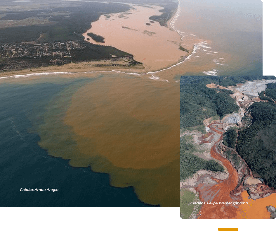
Considered the largest disaster in the world involving tailing dams, the collapse dumped a total volume of 40 million cubic meters, which traveled through the Basin of Doce River, abruptly changing various aspects of community life.

As immediate consequences, the physical displacement of people and the damage to the ecosystem of Doce River, demanded debates and positions on a complex process of repair and compensation of the impacts caused by the disaster. 

The day of disaster

It was on a Thursday of November 5, 2015, around 15h30m, that Fundão dam collapsed, located in the Germano Industrial Complex, in the City of Mariana/MG. In addition to the social and environmental disaster, the tragedy killed 19 people.

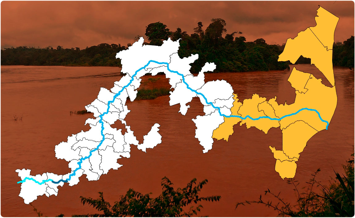
The project was installed in the Gualaxo do Norte River Basin, a tributary of Carmo River, which is a tributary of Doce River. And its collapse caused a “tsunami” with the tailing of iron ore and silica, among other materials. 

The tailing wave hit Santarém dam, further ahead, eroding part of the structure after receiving volumes of water and thunderous tailing. And, at high speed, the wave hit Fundão Stream and Santarém Stream, burying much of the sub-district of Bento Rodrigues, victimizing 19 lives and displacing hundreds of families. 

The avalanche of mud and tailing traveled 55 km until it flowed into Carmo River, directly reaching the communities of Paracatu de Baixo, Camargos, Águas Claras, Pedras, Ponte do Gama, Gesteira, in addition to the Cities of Barra Longa, Rio Doce and Santa Cruz do Escalvado.

The most impactful section of the tailing wave is located between Fundão dam and Risoleta Neves Hydroelectric Power Plant, with the overflow of a large volume of tailing to the preservation areas of Gualaxo do Norte and Carmo rivers, destroying the vegetation cover of the river banks, removing everything on the ground. 

In addition to the losses in vegetation, the tailing destroyed habitats of terrestrial and aquatic animals, both in the basin of Doce River and in the marine environment of the river mouth. 

Incalculable impacts

The losses of rural properties invaded by the mud, lives reaped by the avalanche of tailing and other destruction were immediate impacts of the disaster, but the consequences of the long-term effect of the disaster may be partly irreparable. 

Numerous localities have suddenly experienced the lack of water supply and those who depended on the Doce river to feed or withdraw their livelihood have also suffered since then. 

The indigenous peoples and traditional peoples who worshipped the river, in addition to seeking water and food, also lost a fundamental reference of their culture. In the river, they celebrated life, were baptized and performed rituals and feasts. 

In conclusion, several aspects of the life of the communities were disjointed, in addition to environmental impacts, physical displacement of people, loss of work and damage to the physical and emotional health of the victims of the disaster, debates about reparation, indemnities and resettlement became part of the routine.

INTERACTIVE MAP

CITIES AFFECTED BY THE COLLAPSE

Mapa interativo

Municípios atingidos pelo rompimento

Mapa do desastre
Trajeto do Rio Doce - Minas Gerais Trajeto do Rio Gualaxo do Norte - Espírito Santo Trajeto do Rio do Carmo

45 – CONCEIÇÃO DA BARRA

Conceição da Barra é um município brasileiro do estado do Espírito Santo e o mais oriental do estado. Sua população, segundo dados do Instituto Brasileiro de Geografia e Estatística (IBGE) era de 31.479 habitantes em 2021.

Repair

Timeline

Pesquisa de Satisfação

Como você avalia a plataforma em relação aos seguintes aspectos:

AVALIAÇÃO DA QUALIDADE DOS CONTEÚDOS
AVALIAÇÃO DO USO DA PLATAFORMA

O quanto você recomendaria o acesso à plataforma para outras pessoas?

Skip to content